Friday, October 26, 2012

Far Western Section Field Guide for the Sonora Pass Region available at Sunbelt Publishing!

(Cross-posted from Geotripper)
Our field guide to the geology of the Sonora Pass region and the eastern Sierra Nevada region is now available for sale at Sunbelt Publishing for $24.95 (here is the link)! This was the roadguide for our recent meeting of the Far Western Section of the National Association of Geoscience Teachers. There are quite a few geological road guides out there for the eastern Sierra Nevada, especially around the Mono Lake area, but there have been fewer guides for the area to the north. It is a fascinating area, with wide areas of Miocene volcanism, faulting and Pleistocene glaciations (the largest glaciers of the eastern Sierra Nevada traversed the West Walker River gorge).
One of California's most intriguing ghost towns can be found at Bodie (above), and one can also find a strange "fluvial forest" in the West Walker River, a group of long-dead Ponderosa pines that provide evidence of a century-long mega drought only a thousand years ago (below).
The western slope of the Sierra along the Stanislaus River hides some geological treasures as well, including the Columns of the Giants and the Natural Bridges in the cave country north of Columbia State Park (below).
Here is the table of contents...

A Geographical Sketch of the Central Sierra Nevada
A Brief Overview of the Basement Rocks of the Central Sierra Nevada

Trip 1: The Sierra Crest Graben: A Miocene Walker Lane Pull-Apart in the Ancestral
Cascades Arc at Sonora Pass
by Cathy Busby, Alice Koerner, Jeanette Hagan, and Graham Andrews at the University of California, Santa Barbara
Trip 2: A Guide to the Geology of the Eastern Sierra Nevada between Sonora Pass
and June Lake, California
by Garry Hayes, Modesto Junior College
Trip 3: Geology and Climatology of the Saddlebag Lake Region near
Tioga Pass
, CA by Laura and Ryan Hollister
Trip 4: Sword Lake Debris Flow by Jeff Tolhurst, Columbia College
Trip 5: Unique Geology along the Stanislaus River, Western Central Sierra Nevada by Noah Hughes, Modesto Junior College
 Appendix A: The Flora of Central California: Central Valley to the Great Basin by Mary Cook

A reminder: Sales of this guide will fund the scholarship program of the Far Western Section of the NAGT, which supports geology majors throughout California, Nevada and Hawaii. Check it out!

Monday, October 22, 2012

Evolving Earth Foundation student research grants announced

The 2013 cycle of the annual Evolving Earth Foundation student research
grant program has started. A total of ten grants are available, for amounts
of up to $3000 per grant. Undergraduate students, graduate students, and
post-doctoral researchers at accredited U.S. colleges and universities or
research institutions are eligible to apply for grants.

The Evolving Earth Foundation is dedicated to an increased understanding and
awareness of the geologic and biologic processes that shape our earth. Award
emphasis will be on research topics that relate to the mission and
priorities of the foundation.

Please visit the grant section of the Evolving Earth Foundation Web site for
full grant program details:
http://www.evolvingearth.org/evolvingearthgrants/grantsmain.htm

Sincerely,

Evolving Earth Foundation
http://www.evolvingearth.org

Thursday, October 11, 2012

Alaska Travel Opportunity with NAGT Geology Teachers! July 31-August 10, 2013

Long-time members Wendy Van Norden and Greg Wheeler want to show you the HEART OF ALASKA on an 11 day van trip to some of the most beautiful, unusual, biologically, and geologically significant wilderness in the world. The trip begins in Anchorage Alaska and goes by van to the Wrangell-Saint Elias Wilderness Area (the largest Wilderness Area in the United States). Participants will see the place which once made Kennecott Copper the largest copper mining company in the world, spend a day on the Root Glacier, and hike in the wilderness around McCarthy. They will then drive to Paxson for an afternoon and overnight in log cabins at the beginning of the Denali Highway. The adventure continues for two days of van camping along the Denali Highway on the way to Denali National Park. At the entrance to Denali, they will raft the Nenana River and stay at the Nenana cabins.They will have two adventure filled days in Denali. The last night is in cabins at Beyer’s Lake. The group returns to Anchorage on August 10.

You will see true wilderness, spectacular glaciers, moose, caribou, grizzly bear, and Dall sheep. You will learn about the geology, and biology of this wild part of America AND you will do it, while tent (except for three nights in cabins) and van supported camping. For more information, please download this information sheet.

Monday, September 17, 2012

Oceanography Workshop


Golden Gate Bridge

Golden Gate Bridge, taken from Crissy Field. Image taken by K. Wiese

Workshop: Teaching Oceanography

June 18-20, 2013, with optional field trips on June 17 and 21
Chinatown/North Beach Campus
City College of San Francisco

Application deadline - March 1, 2013
Limited stipends are available to help defray workshop costs; applications for these stipends will be available in Fall 2012. Stipend application deadline - March 12, 2013
This workshop is designed specifically for instructors of Introductory Oceanography. Session topics focus on sharing tested models and strategies for effectively teaching this topic in undergraduate courses. Each participant will contribute tested teaching materials and strategies and participate in the development and review of classroom resources that take advantage of cutting edge technology and pedagogy.


Monday, September 10, 2012

New Geology Guidebook available! Geological Excursions in the Sonora Pass Region of the Sierra Nevada

 (cross-posted from Geotripper)
The newest guide by the Far Western Section of the National Association of Geoscience Teachers is now available for sale! Geological Excursions in the Sonora Pass Region of the Sierra Nevada, edited by Noah Hughes and yours truly, is a series of field trips at Sonora Pass and along the eastern Sierra Nevada as far south as June Lake and Saddlebag Lake near Tioga Pass. Other excursions include significant geologic sites on the Stanislaus River, including the unique Natural Bridges near the town of Columbia.
This is a fascinating region that hasn't always received the attention it deserves. A great deal of recent research has been done on the Miocene volcanism in the region and how it relates to the uplift history of the Sierra Nevada and the development of the Sierra Nevada microplate. The region is part of the Walker Lane, which in all likelihood is the future margin of the North American Plate. There are ghost towns, saline lakes, ancient metamorphic rocks glacial deposits and a strange "fluvial forest" in the West Walker River. There is the strange "Reversed Creek" near June Lake.

Chapters in the book include the following:

A Geographical Sketch of the Central Sierra Nevada

A Brief Overview of the Basement Rocks of the Central Sierra Nevada

Trip 1: Sierra Crest Graben: A Miocene Walker Lane Pull-Apart in the Ancestral
Cascades Arc at Sonora Pass (by Cathy Busby, Alice Koerner, Jeanette Hagan, and Graham Andrews at the University of California, Santa Barbara)

Trip 2: A Guide to the Geology of the Eastern Sierra Nevada between Sonora Pass
and June Lake, California
(by Garry Hayes, Modesto Junior College)

Trip 3: Geology and Climatology of the Saddlebag Lake Region near
Tioga Pass, CA
(by Ryan Hollister of Turlock High School and Laura Hollister of Pitman High School)

Trip 4: Sword Lake Debris Flow (by Jeff Tolhurst, Columbia College)

Trip 5: Unique Geology along the Stanislaus River, Western Central Sierra Nevada (by Noah Hughes, Modesto Junior College)

Appendix A: The Flora of Central California: Central Valley to the Great Basin (by Mary Cook, Modesto Junior College)
The book was prepared for the Fall 2012 meeting of the Far Western Section of the National Association of Geoscience Teachers held last weekend at the High Sierra Institute at Baker Station below Sonora Pass. All proceeds from the sale of the book support scholarships for geology majors in California, Nevada and Hawaii (details of the scholarship can be found here).
At this time, the book can be ordered directly from the Far Western Section at http://nagt-fws.org/publications.html for $29.95 plus shipping and handling (checks only). The web page also includes dozens of other guides for geological tours all over California and Nevada. The guide will soon be available from Sunbelt Publishing, which published the volume (http://www.sunbeltbook.com/). The ISBN number is 978-0-9606704-4-4.
Photo by Ryan Hollister

We are excited to be able to offer this exploration of a fascinating region! If you are interested in seeing some unique landscapes and want to catch up with some new Sierra Nevada research, check it out (and help some worthy students advance their studies in geology at the same time).
Photo by Ryan Hollister
Here is the promised furry animal. The pika is a rodent adapted to living at the highest elevations in the Sierra Nevada. Their habitat is being affected by global warming. They can be seen near Sonora Pass and in the region above Saddlebag Lake.

Sunday, September 2, 2012

Siccar Point to become a garbage dump?

Siccar Point is in the far distance on the left
(Cross-posted from the Geotripper blog)

The abyss of time is about to become a cesspool...

An issue has crossed my desk that ought to be upsetting to anyone who has followed geology as a career or has any passing interest in the history of geology. Siccar Point in southern Scotland is under serious threat of "development". Not development as in hotels and parking lots, but as in "being turned into a pile of sewage". An agricultural company is proposing to cut a pipeline through the point, to be used to transport rotting vegetables and agricultural wastes, untreated, into the sea a very short distance offshore. Information about this desecration and efforts being made to stop it can be found here: http://www.savesiccarpoint.co.uk/. The response time is very short, so I hope that as many geologists as possible will be heard from.
Geotripper lends scale to an outcrop of the crossbedded Old Red Sandstone
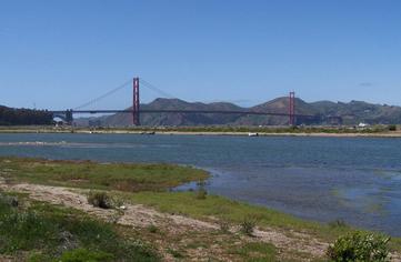
I had a single chance to visit Siccar Point back in 2001. We made all the special arrangements with the touring company to get to the locality on the back roads, but a rather awful incident in Scotland interfered in a big way: hoof and mouth disease. The malady was detected and wholesale destruction of the cattle herds in the country followed. The few unaffected herds were placed in quarantine, and no one was allowed to cross pastures (which was necessary to get to the point). One cannot imagine how disappointed we were. I started studying the maps and realized that a second access point might exist, one that wouldn't threaten any herd animals. We drove to a campground at Pease Bay and started walking along the shoreline (actually, I was running, an act that is legend in our department; it was pretty rugged and I should have broken something). We were able to get within sight of the point (it's the point of rocks in the farthest distance of the top picture; click on the picture for a better view).
Although we couldn't stand on the Siccar Point unconformity, a lesser exposure was visible along the shoreline cliffs.
Why is the point important in the history of geology? There is an angular unconformity between the Old Red Sandstone and the underlying graywacke sandstones that provided the most vivid evidence of James Hutton's revolutionary idea of uniformitarianism, the principle that was the impetus for the modern development of geology as a science. John Playfair's description of his visit to Siccar Point is one of the more stirring descriptions of deep time as you will ever read:


"The ridge of the Lammermuir Hills in the south of Scotland, consists of
primary micaceous schistus, and extends from St. Abb's head westward, till it
joins the metalliferous mountains above the source of the Clyde. The
sea-coast affords a transverse section of this alpine tract at its eastern
extremity, and exhibits the change from the primary to the secondary strata,
both on the south and on the north. Dr. Hutton wished particularly to examine
the latter of these, and on this occasion Sir James Hall and I had the
pleasure to accompany him. We sailed in a boat from Dunglass, on a day when
the fineness of the weather permitted us to keep close to the foot of the
rocks which line the shore in that quarter, directing our course southwards,
in search of the termination of the secondary strata. We made a high rocky
point or headland, the Siccar, near which, from our observations on the
shore, we knew that the object we were in search of was likely to be
discovered. On landing at this point, we found that we actually trod on the
primeval rock, which forms alternately the base and the summit of the present
land. It is here a micaceous schistus, in beds nearly vertical, highly
indurated, and stretching from south-east to north-west. The surface of this
rock runs with a moderate ascent from the level of low-water, at which we
landed, nearly to that of high-water, where the schistus has a thin covering
of red horizontal sandstone laid over it; and this sandstone, at the distance
of a few yards farther back, rises into a very high perpendicular cliff.
Here, therefore, the immediate contact of the two rocks is not only visible,
but is curiously dissected and laid open by the action of waves. The rugged
tops of the schistus are seen penetrating into the horizontal beds of
sandstone, and the lowest of these last form a breccia containing fragments
of schistus, some round and others angular, united by an arenaceous cement.
Dr. Hutton was highly pleased with appearances that set in so clear a light
the different formations of the parts which compose the exterior crust of the
earth, and where all the circumstances were combined that could render the
observation satisfactory and precise. On us who saw these phenomena for the
first time, the impression made will not easily be forgotten. The palpable
evidence presented to us, of one of the most extraordinary and important
facts in the natural history of the earth, gave a reality and substance to
those theoretical speculations, which, however probable, had never till now
been directly authenticated by the testimony of the senses. We often said to
ourselves, What clearer evidence could we have had of the different formation
of these rocks, and of the long interval which separated their formation, had
we actually seen them emerging from the bosom the deep? We felt ourselves
necessarily carried back to the time when the schistus on which we stood was
yet at the bottom of the sea, and when the sandstone before us was only
beginning to be deposited in the shape of sand or mud, from the waters of a
superincumbent ocean. An epocha still more remote presented itself, when even
the most ancient of these rocks instead of standing upright in vertical beds,
lay in horizontal planes at the bottom of the sea, and was not yet disturbed
by that immeasurable force which has burst asunder the solid pavement of the
globe. Revolutions still more remote appeared in the distance of this
extraordinary perspective. The mind seemed to grow giddy by looking so far
into the abyss of time; and while we listened with earnestness and admiration
to the philosopher who was now unfolding to us the order and series of these
wonderful events, we became sensible how much farther reason may sometimes go
than imagination can venture to follow. As for the rest, we were truly
fortunate in the course we had pursued in this excursion; a great number of
other curious and important facts presented themselves, and we returned,
having collected, in one day, more ample materials for future speculation,
than have sometimes resulted from years of diligent and laborious research."

A nice exposure of the Old Red Sandstone near Pease Bay.
Standing at (or near, in my case) Siccar Point should be near the top of any geologist's life list. To mar it with a pipeline and sewage...you might as well build sewage treatment plant in the middle of Stonehenge. This shouldn't be happening. All geologists should be heard from as soon as possible to stop this wanton destruction of one of the most important outcrops in the world. It should be under protection as a World Heritage Site, but instead is subject to abuse and misuse. Please make yourself heard, and soon.

Monday, August 27, 2012

CSU Sacramento Tenure Track Faculty Position in Structural Geology

The Geology Department at California State University, Sacramento invites applications for a tenure-track faculty position at the Assistant Professor level, beginning Fall,  2013.  Applicants must hold a Ph.D. in geology by the time of appointment.  Enthusiasm and a demonstrated commitment to teaching and mentoring are required.  We encourage applicants with field-based research interests and strong skills in geologic mapping.  Proficiency in active tectonics, neotectonics, GPS, GIS, LiDAR and/or other remote sensing applications is preferred. 

The successful candidate will embrace the opportunity to teach general education courses to a diverse student population, conduct a field-based research program that involves undergraduate and graduate geology students, and be a full-engaged participant in a small, collegial department. 

Applicants must submit (1) a cover letter that addresses their qualifications for the position, their teaching interests and experience, and their scholarly interests and experience; (2) a curriculum vita; (3) several examples of the candidates geologic mapping; (4) transcripts of college work (unofficial transcripts are acceptable; to be followed later by official transcripts before hiring); (5) three letters of reference (which may be sent directly to the search committee); and (6) the contact information (mailing address, phone number and email address) for three references who can speak to the professional qualifications of the applicant. Send application material to Chair of Search Committee, Department of Geology, California State University, Sacramento, 6000 J Street, Sacramento, CA 95819-6043. Screening of applications will begin November 2, 2012. 

Additional information can be found at www.csus.edu/geology.

Thursday, August 9, 2012

Time is running out! Register now for the Fall Meeting of the Far Western Section of the NAGT at Sonora Pass!

Time is running out! Register now for the conference (links for registration forms below). We won't be able to take on-site registration at Baker Station. Let us know if you have any questions.

Far Western Section
Fall 2012 NAGT Meeting
Hosted by Modesto Junior College, California
At the High Sierra Institute at Baker Station near Sonora Pass, California
September 7-9, 2012
What is the High Sierra Institute?
The High Sierra Institute (http://www.highsierrainstitute.org/) is located at Baker Station on Highway 108 near Sonora Pass in the Sierra Nevada north of Yosemite National Park. It is located in the center of some of the most fascinating geological features in California. From our base at the institute, we will be able to explore the record of volcanism in the High Sierra and the valleys to the east (including Mono Lake and the ghost town of Bodie), and the glaciation of the range from both sides of the Sierra Crest. We will have access to plutonic and metamorphic rocks of the highest part of the Sierra near Tioga Pass, and the fascinating rocks of the Western Sierra Metamorphic Belt near Sonora and Columbia. This is a great opportunity for local earth science teachers to learn some interesting geology in their home region. Membership is not required to participate, but you will have an opportunity to join NAGT if you wish, and to purchase field guides and resources published by the Far Western Section.


Not your normal Far Western Section Conference!

The High Sierra Institute is in a remote corner of California, and few motels and eating establishments are available in the area. Cell phones don’t work, and internet access isn’t available either. We will primarily be camping, hiking and eating outdoors (there is limited dormitory space at the station itself). This is alpine country, so it may be cool at night, but probably warm during the day. Our meetings and talks will take place under the trees and stars.

We hope to see you there!


Please contact Noah Hughes hughesn at mjc.edu or Garry Hayes hayesg at mjc.edu with any questions about the fall 2012 NAGT Meeting.

Saturday, June 9, 2012

Announcement of the Fall Meeting of the Far Western Section: High Sierra Institute at Baker Station, Sept. 7-9, 2012

If you have ever wanted to spend a few days getting to know the geology and natural history of the Sierra Nevada, here is a great opportunity: the Fall 2012 meeting of the Far Western Section of the National Association of Geoscience Teachers. It will be held at the High Sierra Institute at Baker Station near the summit of Sonora Pass just north of Yosemite National Park. The meeting is sponsored by Modesto Junior College.
Um, the Institute is rustic, but not to this degree! This is Bodie Ghost Town east of the Sierra
The High Sierra Institute at Baker Station is located in the center of some of the most fascinating geological features in California. From our base at the institute, we will be able to explore the record of volcanism in the High Sierra and the valleys to the east (including Mono Lake and the ghost town of Bodie), and the glaciation of the range from both sides of the Sierra Crest. We will have access to plutonic and metamorphic rocks of the highest part of the Sierra near Tioga Pass, and the fascinating rocks of the Western Sierra Metamorphic Belt near Sonora and Columbia. This is a great opportunity for local earth science teachers to learn some interesting geology in their home region. Membership is not required to participate, but you will have an opportunity to join NAGT if you wish, and to purchase field guides and resources published by the Far Western Section.
Sonora Pass reaches 9,623 feet and is the second highest paved highway in the Sierra Nevada. The scenery in the area is spectacular, and includes exposures of the granites of the Sierra Nevada batholith, a complex sequence of Neogene volcanic rocks, and a rich record of Pleistocene glacial activity.
Some of our field trips will take us east of the crest of the Sierra, into the Bridgeport and Mono Lake Valleys. There is a rich record of Plio-Pleistocene volcanism and faulting to investigate, and some of the best glacial moraines to be found anywhere.
Mono Lake is America's "Dead Sea", a vast alkaline lake with strange tufa towers and millions of migratory birds. We will have a chance to talk about environmental challenges at the lake caused by the diversion of incoming streams by Los Angeles.
Here is the complete line-up of events:

Trip 1: Walker Lane Belt Pull-apart Volcanism and the 11- 9 Ma Sierra Crest Graben at Sonora Pass: The one-day field trip will take place at Sonora Pass, in the newly-recognized 11- 9 Ma Sierra Crest Graben. Geologic highlights will include spectacular views of the Sierran crest, and in outcrop we will examine the Miocene graben fill. Basal deposits consist of giant landslide deposits, shed from Early Miocene arc volcanic sections on the graben shoulders. The landslide megablocks provide a smorgasbord of arc volcanic lithofacies, which we will identify in outcrop. The landslide megabreccia is overlain by by graben-ponded latite lava flows, which we will also study in outcrop. The trip will provide also overviews of the topographic evolution of the Sierra Nevada.

            We will spend the day hiking (about 3 – 4 miles round trip), with an elevation gain and loss of about 1,000’. Please wear hiking boots, a sunhat, and a daypack with 2 – 3 quarts of water, lunch, sun screen, and a rain parka/wind breaker.  Tour Leader: Cathy Busby

Trip 2: Geology of the Eastern Sierra Nevada between Sonora Pass and Mono Lake: A tour of some of the eastern Sierra Nevada, including Mono Lake, Black Point, Lundy Canyon, Bodie Ghost Town, Bridgeport Valley, the West Walker River, and Sonora Pass. Easy to moderate hikes only. Leader: Garry Hayes

Trip 3: Geology & Climatology of the Saddlebag Lake Region, Tioga Pass: A five mile hiking tour along the stunningly beautiful eastern crest of the Sierra Nevada just below Tioga Pass in the Twenty Lakes Basin of the Hoover Wilderness Area. Tour will explore the glacially-incised boundary zone between the Sierra Nevada Batholith and the Eastern Metamorphic Belt with a possible spur hike to Conness Glacier, weather and time-permitting. Moderate to strenuous hiking at elevations over 10,000’ is required. Leaders: Ryan and Laura Hollister

Trip 5:  A Tour of the Western Sierra Nevada from Baker Station to Knights Ferry: An exploration of the volcanic, glacial, and karst features of the western slope of the Sierra Nevada. Stops may include the Columns of the Giants, Natural Bridges, and inverted stream of Table Mountain. Easy to moderate hikes only. Leader: Noah Hughes

 Trip 6:   Geology of the Sword Lake Debris Flow: Some moderate to strenuous hiking required. Leader: Jeff Tolhurst, Ph.D., Columbia College

Speakers:

Friday:
Going up or going down? Evidence for late Cenozoic uplift of the Sierra Nevada, California, connection to tectonic and processes, and alternative explanations of paleoaltimetry. John Wakabayashi, Department of Earth and Environmental Sciences, California State University, Fresno.

Saturday:
Walker Lane Belt Pull-apart Volcanism and the 11- 9 Ma Sierra Crest Graben at Sonora Pass Speaker: Cathy Busby Ph.D, UC Santa Barbara
Full details and registration forms are now posted at http://nagt-fws.org/conferences.html. Hope to see you there! Contact Noah Hughes or Garry Hayes for more information.

Sunday, April 22, 2012

Big Map Sale at the US Geological Survey!

Sale at the US Geological Survey (USGS) online store – now is the time to stock up. A huge sale on maps and much more!!!! Thousands of items deeply-discounted to just $1.
http://store.usgs.gov/b2c_usgs/b2c/start/%28xcm=r3standardpitrex_prd%29/.do
  • topographic maps,
  • national park maps
  • forest service maps
  • posters and much more

Tuesday, March 13, 2012

From GSA: Preparing Students in Two-year Colleges for Geoscience Degrees and Careers

Dear Geoscience Education Division Members,

If you are working with community college students or transfer students from community colleges and have an interest in providing them with excellent career resources, great research experiences, internships or short apprenticeship programs to learn more about careers, geotechnical training programs, and/or other career development or workforce development programs and strategies, please read on. Open to faculty and administrators from both two-year/four-year colleges and universities and other agencies or organizations that support community college students.
Preparing Students in Two-year Colleges for Geoscience Degrees and Careers
University of Washington-Tacoma, WA
18-21 July 2012
Application deadline: 19 March 2012

Building a strong and diverse geoscience workforce is a critical national challenge. Two-year colleges (2YCs) play an important role in increasing both the number and diversity of geoscience graduates. This workshop will develop resources, strategies, and recommendations for preparing students in two-year colleges for geoscience careers, either as geotechnical graduates or as geoscience majors at four-year colleges and universities. In addition, the workshop will explore the scope and potential for geoscience technical training (e.g., earth resources, environmental management, and marine technology).

This workshop will bring together geoscience faculty and administrators from two-year colleges, four-year colleges and universities with representatives from professional organizations and government agencies. We will share successful practices in 2YC college-transfer and geotechnical workforce programs, research and internship programs for 2YC geoscience students, and geoscience careers and career resource, and will work together to develop new strategies and recommendations from the classroom to the national level. This workshop will be a great opportunity to share ideas for strategies to promote student success.

The goals of this workshop are to:
• Identify and document the successes and challenges of programs, activities, and resources that support career preparation of 2YC students for the geosciences
• Develop a vision for programs, resources, and materials to improve the preparation of 2YC students for geosciences careers and degrees
• Explore strategies and make recommendations to increase the number and diversity of geoscience professionals coming from two-year colleges
• Establish a network of leaders who will promote and support activities that prepare 2YC students as geotechnicians and geoscience majors

The workshop will include plenary talks, panelist presentations, small and large group discussions, individual presentations or posters, planning/writing sessions, and time for networking and collaboration. Our grant covers travel costs and onsite food and lodging expenses for faculty participants.

More information about the workshop is given on the
workshop webpage , which also has a link to the online application form.

This workshop is part of the program, Supporting and Advancing Geoscience in Two-year Colleges (SAGE 2YC). SAGE 2YC is sponsored by the National Association of Geoscience Teachers and funding is provided by grants from the National Science Foundation Division of Undergraduate Education.

Please forward to others who might be interested in the workshop.

Thanks,

Heather Macdonald, College of William & Mary
Eric Baer, Highline Community College
Robert Blodgett, Austin Community College
Jan Hodder, University of Oregon

Sadredin Moosavi
Chair, GSA Geoscience Education Division
Department of Science
Rochester Community Technical College

Wednesday, March 7, 2012

Nominate an Outstanding Earth Science Teacher of the Year! You Know Someone Who Deserves it

A what?

An Outstanding Earth Science Teacher of the year! There are a lot of teachers out there in California, Nevada and Arizona who are in the trenches of warfare against ignorance and apathy. If you are a teacher, you know the feeling of frustration that can come with students who don't seem to care, and yet you do all you can to make the sciences come alive. And once in a while you find you made a difference. Sometimes it may be years before you find out, but there are always the students who couldn't look like they were interested, but later on, inspired to go to college, they get back to the geological sciences, because of the interest you sparked. Or even better, they become teachers of the geosciences. And sometimes you even hear about it, and sometimes they will come back to thank you.

It's wonderful when that happens, but that also can be a rare event.

If you know a teacher of the earth sciences who tries to go that extra mile to bring the sciences alive, there is another way to grant him or her the recognition that they deserve. You can nominate them to be the Far Western Section's Outstanding Earth Science Teacher of the year. We can never know who the single best teacher is. We can only recognize the ones who deserve a bit of extra attention because they are the ones who put their heart into their work every day.
 
Outstanding Earth Science Teacher (OEST) awards are given for "exceptional contributions to the stimulation of interest in the Earth Sciences at the secondary level." Middle school and high-school teachers are eligible. Only ten national awardees are selected each year, one from each NAGT regional section.
  • 2 year complementary membership in NAGT
  • 3 year complimentary membership in the Geological Society of America (GSA)
  • 3 year complimentary membership in GSA Geoscience Education Division
  • $500 travel funds to a GSA meeting
  • $500 classroom improvement funds from GSA
It is a straightforward process to nominate an OEST. The information can be found here. The deadline is May 1. Give it some thought: someone you know is a truly excellent teacher, and they deserve to know it.

Tuesday, February 28, 2012

Schedule of Events at the March 2-4 Meeting of the Far Western Section at Zzyzx, CA

Check beneath the fold for the final version of the schedule for the events at the spring meeting of the Far Western Section, to be held this weekend (March 2-4). Hope to see you there!

Saturday, February 25, 2012

Honors Earth Science and University of California "d" Level Laboratory Courses

From Wendy Van Nordon at NESTA (National Earth Science Teachers Association):

"Are you interested in teaching an Honors Earth Science class? Would you like to help a local high school teacher to do so? At the website honorsearthscience.com you can find the curriculum of an Honors Earth Science course that was accepted by the University of California as an honors, “d” level laboratory course. It is designed to be a capstone course for 11th and 12th grade college bound high school students. It can easily be adapted to be a dual level course by collaboration with a local college. At the website you will also find a link to an Honors Geology course that is also a dual-credit course, and a podcast explaining the benefits of a dual-credit course. You are encouraged to add your name and the name of your school if you are interested in adopting one of these courses or partnering with a high school teacher who would like to adopt one of the two honors courses. For more information, contact Wendy Van Norden ."

Thursday, February 23, 2012

Acute Need for Geoscientists (From GSA)

From the Geological Society of America:

Acute Demand for U.S. Geoscientists Prompts Call for Higher Ed Action

Boulder, CO, USA – A recent American Geosciences Institute workforce evaluation estimates that by 2021, some 150,000 to 220,000 geoscience jobs will need to be filled. The AGI report notes that at current graduation rates, most of these jobs will not be able to be filled by U.S. citizens.

Citing great concern about the acute need for well-trained, well-educated geoscience graduates to fill the geoscience workforce, Geological Society of America President John Geissman is calling for colleges and universities to recognize the value of strong, adequately supported geoscience departments. High-quality geoscience education, Geissman notes, is essential to understanding and adequately addressing the “very pressing needs of our society,” including sustainability and human-caused climate change, as well as keeping the growing number of geoscience jobs filled by U.S. citizens.

Included in his call for action, Geissman refers to two very recently approved GSA Position Statements that focus on the importance of teaching earth science and expanding and improving geoscience education in institutions of higher learning.

Both position statements are online at www.geosociety.org/positions/. All GSA position statements include suggestions for how to implement and support the call to action.

The Importance of Teaching Earth Science recognizes that basic knowledge of earth science is essential to meeting the environmental challenges and natural resource limitations of the twenty-first century and notes that earth-science education should begin at the K–12 level and include advanced classes led by well-qualified science teachers.

Expanding and Improving Geoscience in Higher Education calls specifically for robust, well-supported geoscience departments not only to ensure an increase in the number of geoscience students available to the workforce but also to provide the training necessary “to address crucial societal issues that have the potential to impact global economic security and the well-being of human populations” across the globe.

John Geissman is a professor at The University of Texas at Dallas, emeritus professor at the University of New Mexico, and Geological Society of America president through 30 June 2012.

Thursday, February 9, 2012

Spring Meeting of the Far Western Section-NAGT in the Mojave Desert at Zzyzx, CA on March 2-4: Updated Information


The spring meeting of the Far Western Section of the National Association of Geoscience Teachers will take place on March 2-4, 2012 at the Desert Studies Center in Zzyzx, California. We appreciate the work that El Camino College is doing to organize the meeting. Field trips will explore the mining history, geologic history, and volcanism of the Mojave Desert, the Quaternary landscape and distribution of biota, and the lava tubes of Pisgah Crater. More information and registration forms can be found on the Far Western Section website at http://nagt-fws.org/conferences.html.

Updated information on the field trips and field trip leaders can be found below the fold:

Monday, February 6, 2012

A Note from Cal Paleo (April 14th)

A note from Cal Paleo:
A brief update concerning registration and abstract submission for Cal Paleo 2012:

The Cal Paleo 2012 website (http://calpaleo.ucr.edu) is now up! We will be adding more information concerning the conference program, parking, lodging, etc. in the next few weeks.

Please register at http://calpaleo.ucr.edu/registration.html. The registration deadline is March 31st, 2012.

In addition to graduate and undergraduate students, post-doctoral researchers, faculty and non-university affiliated researchers are invited to submit abstracts for poster presentations; graduate students will be given preference for oral presentations. Using the downloadable abstract template at http://calpaleo.ucr.edu/abstract.html, please submit abstracts as attachments by email to calpaleo1@gmail.com. Please be sure to include your last name in the subject line. Please also note (in the email body): 1) whether you are a faculty member, post-doc, graduate student, undergraduate student or other and 2) whether you would prefer an oral or poster presentation. Abstracts are due by March 1st, 2012.

Once again, please pass on this information to your paleontological colleagues and students! Also feel free to contact us with any questions or concerns at calpaleo1@gmail.com.

 Hope to see you at UC Riverside on Saturday, April 14th!

Cheers,


Paleobiology Program
Department of Earth Sciences
University of California, Riverside
900 University AveRiverside, CA 92521

Thursday, January 26, 2012

AAPG 2012 Teachers Program, April 23, 2012, Long Beach

Check out this opportunity to sharpen your teaching skills at the AAPG Convention in Long Beach, April 23, 2012:
The American Association of Petroleum Geologists invites K-12 science teachers to join us in exploring new methods and technologies to teach the Earth Science Curriculum. The program will include:

• Presentations of the latest technologies for teaching students the basic concepts of geology and introducing students to field work using resources available on the internet

• Presenters will include: Dr. Tanya Atwater (University of California Santa Barbara; Sharon Milito (AAPG 2011 Teacher of the Year); Wendy Van Norden (Harvard-Westlake High School) and Dr. Robert Negrini (California State University)

• Classroom materials to assist you in applying these techniques

• Luncheon with guest speaker: Dr. Robert Anderson (Jet Propulsion Laboratory, Mars Lander Program, Pasadena, CA)
For more information, check here (PDF)

Wednesday, January 25, 2012

Two New Career Opportunities in Teaching Geology

It's actually been awhile since I've seen any full-time teaching opportunities in the geology or earth science listings of the CCC Registry. This week there are actually two of them, for Bakersfield College and Santa Monica College. There are now a total of four positions open in the California Community College System (Info on openings at Mt. San Antonio College and Santa Barbara City College was posted earlier). Some of the application deadlines are approaching quickly.

If your institution has teaching positions at any level from elementary schools to universities, pass on the information and I will post it here.

Scholarships and Outstanding Earth Science Teachers: Upcoming Deadlines

A note from the national office of NAGT:

NAGT Scholarships for Field Study

NAGT offers $500 scholarships for students to attend field-based courses at any time of the year. In addition, the Association of Women Geologists sponsors two additional scholarships specifically for women in this program. Please pass this information along to students who may be interested in doing field courses. More information and the application instructions can be found on the program website - http://nagt.org/nagt/programs/field_scholarships.html
Application Deadline: February 14
------------------------------------------

Outstanding Earth Science Teachers (OEST) Program

OEST awards are given for "exceptional contributions to the stimulation of interest in the Earth Sciences at the pre-college level." Any teacher or other K-12 educator who covers a significant amount of earth science content with their students is eligible. Ten national finalists are selected, one from each NAGT regional section. Some sections also recognize state winners. Individuals may apply themselves or nominate a colleague for the award. More information and the nomination instructions can be found on the program website - http://nagt.org/nagt/programs/oest.html
Application Deadlines vary by Section but begin as early as March 1
------------------------------------------

Geoscience Teachers in the Park

The Geoscience Teachers in Parks (GTIP) program is a collaborative effort between NAGT and the National Park Service to provide professional development for K12 teachers of geoscience. Elementary, middle school, and high school teachers of geoscience, as well as recent graduates who are prospective geoscience teachers are eligible to take part in this program. The internship involves work at the Mammoth Cave National Park to learn from and collaborate with park personnel, local university staff, contracted researchers, and park partners. More information and the application instructions can be found on the program website - http://nagt.org/nagt/programs/GTIP.html
Application Deadline: March 15

Monday, January 23, 2012

Earth Science (Oceanography and Geology) Opening at Mt. San Antonio College

Past-president Mark Boryta has notified us of a full-time position at Mt. San Antonio College in Earth Science (Oceanography and Geology). The application period ends on March 1, 2012. Full information can be found here, and is reproduced below the fold.

If you have any openings at your institution, please notify us and we will post it on the Far Western Section blog.

Wednesday, January 18, 2012

Cal Paleo on April 14 at UC Riverside


From Cal Paleo...

Dear Colleagues,

We would like to announce that this year’s Cal Paleo will be held at UC Riverside on Saturday, April 14th, 2012. We encourage you to attend and take part in this California paleontological tradition!

The focus of the conference will be on student research: graduate students are invited to give oral or poster presentations and undergraduate students are encouraged to participate through poster presentations (though, subject to availability and advisor request, undergraduates may also give talks). The time allotted for each oral presentation will be 10-15 minutes, depending on the number of speakers.

The deadline for abstract submission is March 1st, 2012. Registration will close on March 21st, 2012. There is no registration fee. Additionally, breakfast, lunch and dinner will be provided on the day of the conference. We will shortly supply further details concerning registration, abstract publication, accommodation and possible Sunday, April 15th activities.

An informational website will be up shortly. An abstract template has been attached to this email and a formal registration form will be sent out soon as well. In the meantime, in order to help us gauge numbers and plan accordingly, please reply as to your interest in attending Cal Paleo: “definitely,” “maybe” or “no.” Also let us know if you wish to be removed from the Cal Paleo mailing list to avoid receiving further emails.

Please direct all email correspondence to calpaleo1@gmail.com.

We hope very much to see you all on April 14th!

Paleobiology Program
Department of Earth Sciences
University of California, Riverside

Sunday, January 15, 2012

Exploring the Mojave Desert with the Far Western Section: Spring Meeting, March 2-4

The spring meeting of the Far Western Section of the National Association of Geoscience Teachers will take place on March 2-4, 2012 at the Desert Studies Center in Zzyzx, California. We appreciate the work that El Camino College is doing to organize the meeting. Field trips will explore the mining history, geologic history, and volcanism of the Mojave Desert, the Quaternary landscape and distribution of biota, and the lava tubes of Pisgah Crater. More information and registration forms can be found on the Far Western Section website at http://nagt-fws.org/conferences.html.

From the conference organizers:

Zzyzx (which is pronounced zy-zicks with emphasis on the "zy") has a colorful history of its own and once was a resort which featured mineral springs and mud baths, and was renowned as a health resort. Some of these facilities are partially preserved and make for wonderful photographic opportunities with the background of Soda Dry Lake. Today, the California State University system has established a consortium which administers the Desert Studies Center, facilitates research in a variety of disciplines, and aids the preservation of the endangered Mohave tui chub.

Baker, California is located 11 miles to the north east from the Desert Studies Center and has a variety of motels, restaurants, gas stations, and other facilities, some of which are quite unique. “Home of the World's Tallest Thermometer” is Baker's claim to fame and the height of the thermometer at 134 feet or 41 meters was selected when the community recorded the highest temperature ever recorded in the United States (in Death Valley) at 134 degrees Fahrenheit in 1913. However, it is also a gateway to Death Valley and other scenic areas of the the Mohave Desert. Many travelers come to know Baker as they fill their gas tanks during their excursions to and from Las Vegas to Los Angeles. Baker is approximately 177 miles or 285 kilometers north east of Los Angeles. Las Vegas, Nevada is located about 88 miles or 142 kilometers to the north east of Baker.

The Desert Studies Center has a meeting room, an area for social gatherings and poster sessions, audio visual capabilities with wireless internet, dormitory facilities (advanced registration required and individuals bring their own bedding or sleeping bag), shower facilities, a chef who will prepare the hot breakfasts, dinners and packaged lunches, a store which features items related to Zzyzx, wonderful star gazing opportunities (clear skies permitting), and a wonderful view of Soda Dry Lake, the California Fan Palms and the Chub Pond. All of the field trips will leave from the Desert Studies Center.